Best 1 Topographic Maps And Plotting Tools For Camping And Hiking in the USA for 2026
Published on Tuesday, June 2, 2026
Navigating the vast and diverse wilderness of the United States requires reliable gear, making topographic maps and plotting tools for camping and hiking essential for any serious outdoor enthusiast. This category encompasses both traditional paper and modern digital topographic maps, alongside precision plotting tools like protractors and map scales used to plan routes, measure elevation, and calculate distance. In 2026, USA consumer preferences heavily favor hybrid navigation systems. Hikers and backpackers are increasingly drawn to waterproof, tear-resistant paper maps for fail-safe reliability, paired with digital apps that offer offline map downloads and printable custom route maps. This dual approach ensures safety when venturing off the grid in areas like the Rocky Mountains or the Appalachian Trail, appealing to adventurers who refuse to rely solely on battery-powered devices in unpredictable environments.
Top Picks Summary
AllTrails+ offers an easy-to-use offline topographic map experience backed by one of the largest trail databases and extensive user reviews, making offline topo downloads simple and immediately useful for day hikers and casual outdoors enthusiasts. It is financially attractive as a single subscription that unlocks offline maps across many trails, though its topo detail and advanced export/geospatial features are less technical than Gaia or Avenza for professional mapping needs.
Show More Waterproof Paper Topographic Maps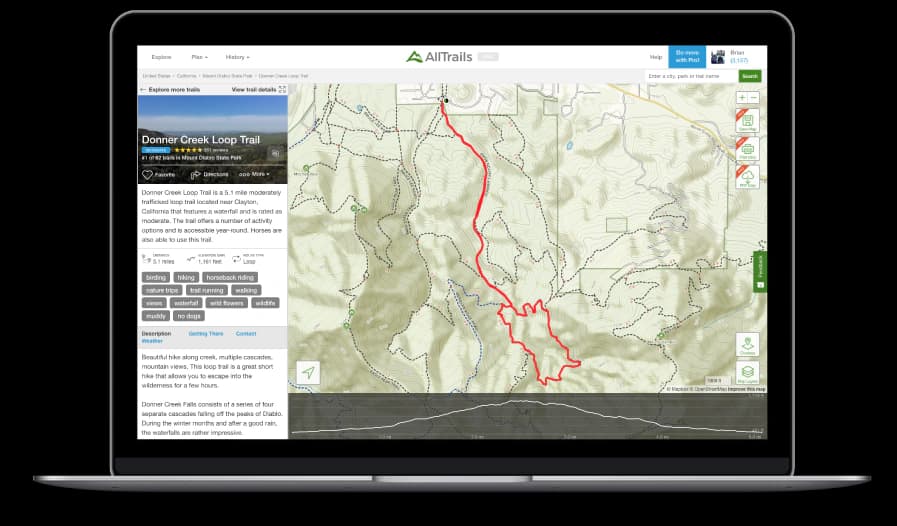
How to Choose the Right Topographic Maps and Plotting Tools
The true difference between a reliable navigation setup and a frustrating one comes down to material durability and scale accuracy. Great topographic maps offer tear-resistant, waterproof construction and precise contour intervals, while the best plotting tools provide high-contrast, scratch-resistant markings that align perfectly with standard map scales.
Check the contour interval before buying; a 40-foot interval is standard for mountainous terrain, but you will want a 10-foot or 20-foot interval for flatter areas to accurately gauge elevation changes.
Ignore marketing claims about universal plotting tools and ensure the roamer scales on your protractor specifically match the scale of your preferred maps, such as 1:24,000 for USGS standard quads.
For physical maps, prioritize synthetic materials like Tyvek or polyurethane-coated paper over standard laminated paper, as they fold easier, resist cracking in freezing temperatures, and are completely waterproof.
If relying on digital map subscriptions, verify that the platform allows unlimited offline downloads and high-resolution PDF exports for printing your own custom backup maps.
Frequently Asked Questions
Which topographic map tool is best for casual day hikers?
AllTrails+ Offline Maps is the ideal choice for casual hikers because it provides an easy-to-use interface backed by a massive database of American trails and community-verified route details.
Does AllTrails+ Offline Maps include satellite imagery for navigation?
Yes, AllTrails+ Offline Maps includes both downloadable topographic and satellite maps to assist with your navigation needs while out on the trail.
How much does the AllTrails+ Offline Maps subscription cost?
The AllTrails+ Offline Maps service is available for a listing price of $0.00 USDmaking it a highly accessible option for hikers looking to download maps for offline use.
What is the user rating for AllTrails+ Offline Maps?
AllTrails+ Offline Maps holds an average rating of 4.5 stars, reflecting its popularity among users who rely on its community-curated routes and offline map access.
Conclusion
Whether you are planning a weekend trip to a local state park or a month-long expedition across the Pacific Crest Trail, having the right topographic maps and plotting tools is vital for a safe journey in the USA. We hope this guide has helped you find the perfect navigation gear to keep you on track and confident in the backcountry. If you need to refine your options or expand your search for specific regional maps or advanced compasses, please use the search bar to explore more top-rated equipment.