Top 7 Marine GPS Chartplotters in the USA for 2026
Published on Tuesday, July 21, 2026
Marine GPS chartplotters are essential for navigating waterways with precision. They offer advanced navigation features tailored for marine use, ensuring you stay on course safely. In the USA, where vast and intricate waterways can pose challenges even to experienced mariners, demand for reliable, high-performing chartplotters continues to grow. Modern chartplotters combine high-resolution charts, multi-frequency GPS and GNSS support, AIS overlays, integrated sonar and fishfinding, radar and autopilot networking, and intuitive touchscreen or hybrid controls. Consumers in the US prioritize accuracy, ease of use, chart coverage from providers like NOAA, Navionics, and C-MAP, ruggedness and IP protection, seamless integration with onboard electronics, and strong vendor support. Boaters, anglers, and commercial operators choose units that reduce navigation workload, help avoid hazards and shallow water, improve situational awareness, and enhance fishing productivity. This category covers devices optimized for coastal cruising, offshore passages, lake and river navigation, and dedicated fishing vessels.
Top Picks Summary
Garmin GPSMAP 943xsv
The Garmin GPSMAP 943xsv is a top-of-the-line marine GPS unit that stands out with its high-resolution touchscreen display, CHIRP traditional sonar, and ClearVü and SideVü scanning sonar capabilities. It offers detailed mapping features and connectivity for radar, autopilot, and other marine devices, making it a versatile choice for serious anglers and boaters.

Simrad NSX 3009 Chartplotter
The Simrad NSX 9 combines reliable chartplotting with clear coastal and offshore navigation features at an accessible price, making it a best-in-class choice for cruisers who want strong core functionality without the premium cost of top-tier systems. Its intuitive interface, solid chart support and good networking options give it a financial advantage over higher-priced competitors like the Raymarine Axiom2 Pro, while still offering more polished chart tools than many entry-level Garmin units.

Raymarine Axiom2 Pro 9 S
The Raymarine Axiom2 Pro 9 S stands out as a market leader for chartplotting performance, with a powerful processor, high-resolution display and Raymarine's LightHouse OS that deliver faster chart redraws and superior integration with advanced sensors. Its technical edge in display clarity and system responsiveness justifies the premium compared with the Simrad NSX and Garmin ECHOMAP, and it outperforms many rivals in large-boat networking and multifunction integration for professional or serious recreational users.

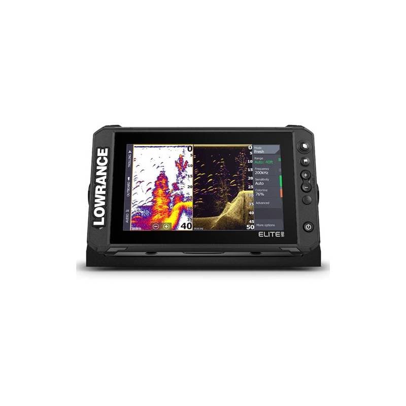
Lowrance Elite FS 9
The Lowrance Elite FS 9 is a versatile fishfinder and chartplotter that stands out for its ActiveTarget Live Sonar technology, offering real-time views of fish movements below the boat. Equipped with C-MAP Genesis Live mapping, it allows anglers to create custom contour maps of uncharted waters. Its touchscreen display and wireless connectivity make navigation and fishfinding a breeze.
Humminbird SOLIX 10 CHIRP MEGA SI+ GPS G3
The Humminbird SOLIX 10 CHIRP MEGA SI+ G3 earns its place for sonar-first chartplotting setups by pairing a 10" display with MEGA Imaging+ and CHIRP sonar that deliver exceptionally detailed bottom and structure images alongside full chartplotter capability. Technically it offers superior target separation and underwater detail compared with the Simrad and Garmin models, and it often represents a strong value for anglers who prioritize advanced sonar imaging over the higher integration features of the Raymarine flagship.

Garmin ECHOMAP UHD 93sv
The Garmin ECHOMAP UHD2 93sv is a value-oriented chartplotter that balances reliable mapping, Quickdraw contour creation and ClearVü/SideVü imaging at a competitive price point for coastal and offshore boaters. It is typically more budget-friendly than the Raymarine Axiom2 Pro while offering better mapping and ecosystem support than many basic units, though its imaging resolution and processing headroom are generally a step below the Humminbird MEGA SI+ and Raymarine's top-tier displays.

B&G Zeus3S 9
The B&G Zeus3S 9 is a top-tier sailing chartplotter that excels in its sailing-specific features, such as SailSteer and RacePanel tools for optimizing performance. With full support for radar, autopilot, and instrument systems, this unit is an ideal choice for competitive sailors and cruising enthusiasts. Its sunlight-viewable display and intuitive interface offer a seamless navigation experience.

Research and evidence supporting chartplotter benefits
Scientific research, government agency reports, and nautical safety studies consistently show that electronic navigation systems and integrated marine electronics reduce navigational errors and improve situational awareness. Evidence highlights gains in positional accuracy, hazard avoidance, and collision reduction when GPS, AIS, and digital charting are correctly used and maintained. For recreational and commercial operators, integrated chartplotter systems that combine positioning, chart overlays, and sensor fusion (radar, sonar, AIS) support better decision making and lower the risk of grounding or collision. The following points summarize accessible research-backed benefits for beginners and experienced mariners alike.
Improved positioning accuracy: Advances in multi-constellation GNSS (GPS, GLONASS, Galileo) and augmentation services reduce position error and increase reliability compared with early single-constellation receivers.
Collision avoidance: Reports from maritime safety agencies note that combining AIS data with electronic chart displays improves vessel tracking and helps reduce close-quarters incidents in congested waters.
Grounding and hazard reduction: Studies and incident reviews indicate electronic charts with up-to-date bathymetry and automated depth alarms lower the frequency of groundings when users maintain current charts and follow alerts.
Human factors and workload: Research in human factors shows integrated displays and clear symbology reduce navigation workload and errors, especially when information is organized with layered chart and sensor overlays.
Fishing efficiency: Academic and industry evaluations of sonar and CHIRP imaging show enhanced target resolution and species-habitat discrimination, which helps anglers find and target fish more effectively.
Frequently Asked Questions
Which marine chartplotter should I buy for my cruiser?
If you want core chartplotting with networking and a 9-inch hybrid touch+keys interface, consider the Simrad NSX 9 (4.7 rating); it supports C-MAP/Insight charts and NMEA 2000/0183 plus Ethernet, priced at $1699.
What sonar features does the Garmin GPSMAP 943xsv support?
The Garmin GPSMAP 943xsv supports CHIRP traditional sonar plus ClearVü and SideVü scanning sonar, and it has a high-resolution touchscreen for advanced GPS navigation; rating is 4.5 and price is $1,599.99 USD
How does the Raymarine Axiom2 Pro 9 S price compare?
At $2,799.99 USDthe Raymarine Axiom2 Pro 9 S costs more than the Garmin GPSMAP 943xsv ($1,599.99 USD) and Simrad NSX 9 ($1,599.99 USD), while adding a 9-inch high-definition IPS touchscreen and LightHouse OS with full networking for autopilot and radar.
Does the Simrad NSX 9 connect to radar and autopilot?
Yes—Simrad NSX 9 includes NMEA 2000/0183 and Ethernet networking for radar, autopilot, and sensor integration, with a 9-inch high-contrast multi-touch display plus supplemental keypad control; rating 4.7 and price $1699.
Conclusion
This selection highlights seven top marine chartplotters you can trust in the USA for 2026: Garmin GPSMAP 943xsv, Simrad NSX 9, Raymarine Axiom2 Pro 9 S, Lowrance Elite FS 9, Humminbird SOLIX 10 CHIRP MEGA SI+ G3, Garmin ECHOMAP UHD2 93sv, and B&G Zeus3S 9. Each model delivers a strong mix of navigation, sonar, and connectivity features for different boating styles. For an all-around best choice on this page we recommend the Garmin GPSMAP 943xsv for its balance of charting detail, sonar performance, and broad ecosystem support. We hope you found what you were looking for. You can refine or expand your search using the site search to compare screen sizes, chart bundles, sonar options, and networking features.